


Mont Caly - Mont Chéry

i20
User
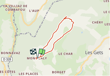

Length
5.7 km

Max alt
1819 m

Uphill gradient
335 m
Km-Effort
10.1 km

Min alt
1493 m

Downhill gradient
338 m
Boucle
Yes
Creation date :
2021-11-11 12:53:32.366
Updated on :
2021-11-11 15:01:00.698
2h07
Difficulty : Medium

FREE GPS app for hiking
 SityTrail
IGN / Geographical institutes
SityTrail Plus
The world is yours!
About
Trail Walking of 5.7 km to be discovered at Auvergne-Rhône-Alpes, Upper Savoy, Les Gets. This trail is proposed by i20.
Positioning
Country:
France
Region :
Auvergne-Rhône-Alpes
Department/Province :
Upper Savoy
Municipality :
Les Gets
Location:
Unknown
Start:(Dec)
Start:(UTM)
317111 ; 5113746 (32T) N.
Comments